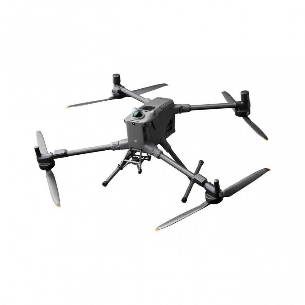
DJI Matrice 400 Worry-Free Plus Combo
$ 98.39

Description DJI Matrice 400 Built for excellence, designed for multifunctionality The DJI Matrice 400, the leading drone platform for business, features an impressive 59-minute flight time[1], a payload capacity of up to 6 kg[2] and built-in rotating LiDAR and mmWave radar for obstacle detection at the power line level[3]. It also supports O4 Enterprise Enterprise Enhanced Video Transmission and Airborne Relay Video Transmission[4], ensuring safer handling and easier operations. Combining Smart Detection with visible and thermal imaging, AR viewing, shipboard take-off/landing and advanced automation, the Matrice 400 excels in emergency response, power inspections, mapping and AEC. Prolonged flight time, high-speed performance The flight capabilities of the Matrice 400 are excellent, offering up to 59 minutes of forward flight time even with a payload, and up to 53 minutes of hovering time[6]. These capabilities make it a reliable tool for long-term and continuous operations such as search and rescue, firefighting and large-scale mapping. It can also avoid large obstacles[3] such as buildings and mountains at flight speeds of up to 25 m/s. Multiple payload, multiple scenery The strong load capacity of the Matrice 400 allows it to easily meet the requirements of a wide range of applications. With a maximum load capacity of 6 kg, the Matrice 400 supports seamless switching between a single cathode gimbal and a dual cathode gimbal. It also features a third gimbal slot on the underside for added flexibility. The aircraft is equipped with 4 external E-Port V2 ports, allowing the simultaneous installation of up to 7 payloads. Depending on the job, the Matrice 400 can be equipped with the Zenmuse H30, L2, P1, S1 Spotlight, V1 Speaker, Manifold 3 or third-party payloads, expanding its capabilities and unleashing the full potential of the DJI ecosystem. Zenmuse H30 series[8] The Zenmuse H30 series incorporates five main modules – a wide-angle camera, a zoom camera, an infrared thermal camera, a laser rangefinder and an NIR auxiliary light. Using innovative intelligent algorithms, it revolutionizes patterns of perception and visualization, overcoming the limitations of day and night vision. Zenmuse L2[8] The Zenmuse L2 incorporates frame-based LiDAR, a self-developed high-precision IMU system and an RGB mapping camera with a 4/3 CMOS sensor, providing DJI’s multi-payload drone platform with more accurate, efficient and reliable geospatial data acquisition. Zenmuse P1[8] The Zenmuse P1 incorporates a full-frame sensor with interchangeable fixed-focus lenses on a 3-axis stabilized gimbal. Designed for photogrammetry missions, it offers new levels of efficiency and accuracy. Zenmuse S1[8] The Zenmuse S1 is DJI’s first projector designed for drone platforms with multiple payloads. Using LEP technology, it offers high brightness and long illumination distance and supports multiple lighting modes. This makes it ideal for public safety operations, emergency rescues, inspections and other night missions. Zenmuse V1[8] Zenmuse V1 is DJI’s first loudspeaker designed for drone platforms with multiple payloads. It features high volume and long transmission range, and supports multiple broadcast modes, making it ideal for applications such as public safety, emergency rescues and more. Manifold 3[8] Manifold 3 packs an impressive 100 TOPS of computing power into a compact unit weighing around 120 g. It can be mounted on the Matrice 400 drone platform, optimising efficiency in various operational missions thanks to its powerful processing capacity. Flight time[1] Estimated flight time of the Matrice 400 based on payload configuration. Safe and reliable flight Built for tough conditions The Matrice 400 has an IP55 protection rating[9], allowing it to operate reliably in harsh conditions such as heavy dust or rain. It also maintains stable performance in temperatures from -20° to 50°C, providing consistent results in both hot and cold conditions. Obstacle detection at power line level[3] The Matrice 400’s advanced obstacle detection system incorporates rotating LiDAR, high-precision mmWave radar and full-colour fisheye vision sensors for low light[13], taking detection capabilities to unprecedented levels. The system detects even small obstacles, such as high-voltage lines in mountainous terrain – even in the dark[3]. It can penetrate rain and fog to detect its surroundings, providing improved safety in difficult weather conditions. Powerful video transmission O4 Enterprise Enterprise Enhanced video transmission system Thanks to the ten antenna system on board the aircraft and the high gain phase antenna system on the remote control, the O4 Enterprise Enterprise Enhanced video transmission system can achieve image transmission of up to 40 km[10]. The Matrice 400 also supports the sub2G frequency band[5] and when equipped with two DJI Cellular Dongle 2[11], it can automatically switch to the best available carrier network, providing a more stable signal even in urban interference environments or remote areas. Real-time airborne video relay[5] The Matrice 400 has an integrated video transmission relay module. With this setup, a Matrice 400 can serve as a relay drone, flying high to provide relay signals for another Matrice 400 operating at a greater distance. This feature significantly extends the transmission range, making it ideal for search and rescue operations, as well as for inspections in mountainous areas. Aircraft position merger The omnidirectional sensing performance[12] offered by the rotating LiDAR, high precision mmWave radar and full colour fisheye vision sensors in low light conditions provide the Matrice 400 with powerful positioning capabilities. It can fly steadily near buildings with glass facades or wind turbine blades and return safely from the edges of buildings, the bases of mountains or the sides of bridges, even when the return point is not known. Full colour vision assistance The four full-colour fisheye low-light sensors on board provide Full-Colour Vision Assist[13] to ensure safer flight. Improved intelligence and efficiency Smart Detection[14] With the visible and thermal imaging of the Zenmuse H30 series, the Matrice 400 can detect vehicles, vessels and objects during search and rescue operations or tactical flights. It also supports migration to other models, allowing the expansion of application scenarios. In addition, it supports high-resolution grid photos and has powerful monitoring capabilities. Smart augmented reality projection Augmented reality power line When performing tasks such as inspecting the power grid, the obstacle detection system automatically detects obstacles, such as cables ahead[3], and displays easily recognisable augmented reality (AR) lines on the remote control screen, making the environment clear at a glance and ensuring a safer flight. View augmented reality map When operated during the day or night in urban areas, the remote control can display the names of buildings and landmarks in real time, marking the main streets with visible lines. Augmented reality flight points Real-time route preview is available for the drone during RTH, obstacle detection and FlyTo operations. During landing, the shadow of the augmented reality aircraft can be displayed to help pilots confirm the landing location. Live notes Without modelling, you can mark points on the remote’s screen to locate subject locations, draw lines to measure distances between multiple points, and describe areas to calculate their size. The measurement results can be synchronized with the DJI FlightHub 2 to improve the efficiency of the team. Real-time ground monitoring The Matrice 400 supports real-time ground monitoring in any horizontal direction[15]. This function can be activated both during manual flight and during automated flight paths, ensuring a constant relative altitude to the ground. During large-scale search and rescue operations, the size of ground subjects can be kept constant on the remote control screen, reducing the need for frequent zoom adjustments and improving efficiency. During mapping missions, a constant ground sampling distance (GSD) can be maintained to obtain high accuracy mapping data. Taking off and landing on ships[16] To meet the needs of offshore operations, such as maritime patrol and wind turbine inspection, the Matrice 400 is equipped with the ability to take off and land on ships, supporting take-off from stationary vessels and landing on moving vessels. By detecting landing point patterns on the deck, it can achieve safe and accurate landings. Smart flight functions Cruise Activate Cruise Control to steer the drone in a specific direction without constantly pressing the control levers, making long-distance flights or linear inspections easier. FlyTo In emergency or disaster situations, the drone can automatically adjust its flight path and speed based on the environment, allowing it to reach a designated location without manual adjustments. Smart Track The Smart Track feature allows for precise subject placement and automatic zoom settings, allowing you to easily switch between subjects. It can automatically retrieve a topic even if it has been shaded for a while. POI POI allows continuous observation and 3D modeling of buildings while they are in orbit around a defined area, greatly enhancing the efficiency of fixed-point observation and modeling operations. Easier automated operations Power line monitoring with Zenmuse L2 When equipped with the L2 LiDAR system, the Matrice 400 can perform automated post-flight power transmission and distribution. It uses rotating LiDAR to detect obstacles in real time and automatically bypasses crossing lines. Slope path and geometric path The Matrice 400 supports the planning and execution of slope and geometric paths via DJI Pilot 2 or DJI FlightHub 2. Whether conducting detailed aerial surveys of building facades, slopes or other inclined surfaces, or collecting mapping data of individual buildings or structures, the Matrice 400 can quickly plot slope or geometric paths to efficiently acquire highly accurate data. Software designed for industries DJI FlightHub 2 Specifically for the Matrice 400, the DJI FlightHub 2 has been upgraded to enable remote control via the cloud, allowing operators to control the aircraft’s flight attitude and official payloads, as well as perform remote takeoff, landing and Live Flight Controls. In addition, it supports a wide range of flight path planning functions, including gradient paths, geometric paths and other advanced path types. During operations with multiple drones, operators can remotely synchronize and view multiple live streams on monitors, creating a new, efficient integrated air-to-ground operating experience. * Users who purchase the Matrice 400 and connect it to FlightHub 2 after activation will receive live streaming minutes, map image limits and cloud storage. DJI Terra DJI Terra is a 3D model reconstruction software that has photogrammetry as its core technology. It supports accurate and efficient 2D and 3D reconstruction using visible light data, as well as point cloud data reconstruction and processing with DJI Zenmuse L2. The DJI Terra is ideal for the DJI Matrice 400 and its payloads. It works together to create a comprehensive application solution that covers vertical scenarios such as land surveying and mapping, power line inspection, emergency response, construction and forestry. DJI Modify DJI Modify provides intelligent processing of 3D mesh and point cloud models. When combined with the Matrice 400 and DJI Terra, it can create a complete solution that covers aerial capture, modeling, model repair and sharing. Open developer ecosystem Intelligent algorithm programmer It provides the necessary model training tools and third-party developer certification process to access embedded computing power capabilities, helping to expand new application areas for drones. PSDK The newly upgraded E-Port V2 supports high-speed USB 3.0 payload communication and provides up to 120 watts of power per port. The E-Port V2’s E4 port can be expanded to four payload ports via the E-Port Hub expansion plate, unlocking wider application scenarios and greater capabilities for the Matrice 400. MSDK Mobile SDK 5 simplifies the development of applications for controlling the Matrice 400. It features fully open source, production-level code samples, with key modules adapted from the DJI Pilot 2, guaranteeing high reliability. Cloud API With the DJI Pilot 2’s built-in Cloud API (MQTT-based protocol), you can connect the Matrice 400 directly to third-party cloud platforms. Access the drone’s footage, live video stream and photo data without having to develop an app. Open access to data Developers can leverage the payload, LiDAR, mmWave radar and vision sensor data interfaces to create innovative applications and expand the DJI ecosystem. User data security Multimedia data encryption Local data function Delete logs with one tap AES-256 video transmission encryption Cloud API Implementation scenarios Public safety Power Line Inspection Geographical information Oil and gas Renewable energy sources Water conservation Marine Roads and bridges * Always check and strictly comply with local laws and regulations before flying. ** All data on this page was collected with a production model of the DJI Matrice 400 in a controlled test environment. The actual experience may vary depending on the environment, usage and firmware version. *** All videos and photos on this page were taken in strict compliance with local laws and regulations. Displays, including wildlife, were taken from a safe distance and are used for reference only. Please comply with local laws and regulations and make sure that the aircraft has received the relevant certifications prior to flight. **** Before use, the Matrice 400 must be activated via the DJI Pilot 2 app. Notes: It was measured with the aircraft flying forward at a constant speed of 10 m/s in a windless environment at sea level, carrying only the H30T (total weight 10,670 g) and from 100% battery level to 0%. The data is for reference only. The actual experience may vary depending on the environment, usage and firmware version. The payload of 6 kg is measured in the third gimbal slot at sea level conditions. Payload capacity decreases as the altitude increases. For details, please refer to the official user manual. Obstacle detection capability on a transmission line: when you are directly opposite a transmission line (aluminium wire with 21.6 mm steel core), obstacle detection is supported at speeds of up to 25 m/s. When both transmission lines (aluminium wire with 21.6 mm steel core) and distribution lines (aluminium wire with 12 mm steel core) are present, obstacle detection is supported at speeds of up to 17 m/s. Obstacle detection performance may vary depending on environmental conditions (such as clouds, fog, rain or snow), as well as the material, location and shape of the target object. Due to the limitations of the safety system, the aircraft cannot avoid active fast-moving objects. Please fly with caution in such environments. See the user manual for more information. The mmWave radar function is not available in some countries/regions. This feature is not available in countries or regions without 5GHz frequency support. See local laws and regulations for more information. The permitted operating frequency varies between countries and regions. See local laws and regulations for more information. It was measured with the aircraft hovering in an airless environment at sea level, carrying only the H30T (total weight 10,670 g) and from 100% battery level to 0%. The data is for reference only. Actual usage time may vary depending on flight mode, accessories and environment. The E-Port V2’s E4 port can be expanded to four payload ports via the E-Port Hub expansion plate. For more detailed information, visit https://developer.dji.com/payload-sdk to find out more. Sold separately. Follow the requirements stated in the IP55 protection rating instructions. Measured in a controlled environment. The IP rating is not permanently effective and may be reduced due to product wear and tear. It was measured in FCC compliance in an unobstructed environment with low interference at a flight altitude of approximately 120 meters. The data is for reference only. During your flight, pay attention to the reminders in the app. To use Enhanced 4G Transmission, the remote must be equipped with the DJI Cellular Dongle 2 (sold separately) or connected to the internet via Wi-Fi. This service is not available in some countries and regions. Consult your local representative for details. There are some blind areas of optical detection and infrared detection. Positioning and obstacle detection performance may be affected by the flight environment and obstacle characteristics. Fly with care. When the ambient light is below 12 lux, the optical sensor switches to black and white mode. Zenmuse H30 series is required. DJI FlightHub 2 is required. It is recommended to use the function when the ship’s speed is below 10 knots and the wind speed is below 5 m/s. Be careful in other environments. It is recommended that you reserve a 3 m × 3 m take-off and landing area on the deck. Standard landing point pattern files are available on the download page. The following accessories are all compatible with Matrice 400. The charging time is measured based on 220 volts. Measured in a controlled environment. Results may vary depending on the environment, actual usage and firmware version. Service offers may vary by country or region. For details, consult your local representative. Free Repairs: Receive free repairs within the scope and amount of coverage. Coverage for your entire fleet: Shared coverage can be extended to other DJI Enterprise devices connected to DJI Care Enterprise Plus within the same time period (30 calendar days) after the first activation and connection. Free Shipping: Available in areas covered by DJI Care Enterprise. Users are responsible for additional costs, including logistics and customs duties, incurred beyond the scope of coverage. The official extended warranty covers the following components: aircraft body, smart battery station, remote control, single gimbal unit down, dual gimbal unit down and third gimbal link. Aircraft Take-off weight (with propellers) Without batteries: 5020±20 g With batteries: 9740±40 g The actual weight of the product may vary due to differences in batch materials and external factors. Maximum take-off weight 15,8 kg Dimensions Open: 980×760×480 mm (W×D×W) (with landing gear) Open: 490×490×480 mm (W×W×D) (with landing gear and gimbal) Maximum dimensions without the propellers. Aircraft carry case dimensions: 779×363×528 mm (W×D×H) Maximum payload 6 kg The payload of 6 kg is measured on the third gimbal link in sea level conditions. Payload capacity decreases as altitude increases. For details, please refer to the official user manual. Propeller size 25 inches Diagonal wheelbase 1070 mm Maximum speed of ascent 10 m/s Maximum descent speed 8 m/s Maximum horizontal speed (at sea level, without wind) 25 m/s Maximum take-off altitude 7000 m Maximum flight time (without wind) 59 minutes Measured with the aircraft flying forward at a constant speed of 10 m/s in a windless environment at sea level, carrying only the H30T (total weight 10,670 g) and from 100% battery level to 0%. The data is for reference only. The actual experience may vary depending on the environment, usage and firmware version. Max hovering time (no wind) 53 minutes It was measured with the aircraft hovering in a windless environment at sea level, carrying only the H30T (total weight 10,670 g) and from 100% battery level to 0%. The data is for reference only. Actual usage time may vary depending on flight mode, accessories and environment. Max flight distance (no wind) 49 km It was measured with the aircraft flying forward at a constant speed of 17 m/s in a windless environment at sea level, with no external payloads and from 100% battery level to 0%. The actual experience may vary depending on the environment, usage and firmware version. Maximum wind speed resistance 12 m/s Maximum wind speed resistance during take-off and landing. Maximum angular deflection speed Deflection: 100°/s Max tilt angle 35° Operating temperature -20° to 50°C (without solar radiation) Global Navigation Satellite System (GNSS) GPS Galileo BeiDou GLONASS* * GLONASS is supported only when the RTK module is enabled. Equipped with a standard ADS-B In receiver and dual antennas, supporting reception up to 20 km. Swing accuracy range (with moderate or no wind) Vertically: ±0.1 m (with optical positioning) ±0.5 m (with satellite positioning) ±0.1 m (with RTK positioning) Horizontal: ±0.3 m (with optical positioning) ±0.5 m (with satellite positioning) ±0.1 m (with RTK positioning) RTK GNSS accuracy RTK correction: 1 cm 1 ppm (horizontal), 1,5 cm 1 ppm (vertical) Direction RTK Supports RTK direction with better than 2° accuracy ADS-B Login from Aircraft Equipped with a standard ADS-B aircraft input receiver and dual antennas, supporting reception up to 20 km. Internal storage D/D Ports USB-C debug port × 1: USB 2.0 E-Port V2 × 4: At the bottom of the drone, with a 120W power port Cellular Dongle 2×2 interface: at the bottom of the drone Propeller model 2510F Lighthouse Built into the aircraft Degree of protection IP55 The rating is not permanently effective and may decrease due to product wear and tear. Gimbal Maximum payload for a Gimbal link 1400 g If it exceeds the value, the life of the gimbal shock absorber will be reduced from 1000 hours to 400 hours. Maximum payload for double Gimbal link 950 g Maximum payload for third Gimbal link 3 kg for quick release port, 6 kg for screw fixing Detection system Type of detection Omnidirectional binocular vision system (surrounding image provided by full colour fisheye sensors) Horizontally rotating LiDAR, upper LiDAR and 3D downwards infrared sensor Six-way mmWave radar Forward Measuring range: 0.4-21 m Detection range: 0.4-200 m Field of view (FOV): 90° (horizontal), 90° (vertical) Backward Measuring range: 0.4-21 m Detection range: 0.4-200 m Field of view (FOV): 90° (horizontal), 90° (vertical) Laterally Measuring range: 0.6-21 m Detection range: 0.5-200 m Field of view (FOV): 90° (horizontal), 90° (vertical) Downstairs Measuring range: 0.5-19 m The front and rear fields of view are 160° and 105° left and right. Operating environment Front, back, left, right and top: fine texture on the surface, sufficient light. Below: The ground has rich textures and adequate lighting conditions*, with a diffuse reflective surface and reflectivity greater than 20% (such as walls, trees, people, etc.). * Adequate lighting conditions refer to light intensity not lower than that of a night-time urban scene. Rotating LiDAR Typical measurement range: 0.5-100 m @ 100,000 lux with a target reflectivity of 10% Measuring range for power line: 35 m @ 30° @ 10,000 lux for aluminium wire with 21.6 mm steel core with a relative body tilt angle of 30° to the left and right Field of view (FOV): 360° (horizontal), 58° (vertical) Point frequency: 520,000 points/second Laser wavelength: 905 nm Eye safety level: Class 1 (IEC60825-1:2014), eye safe Upper LiDAR (3D ToF) 0.5-25 m at night (reflectivity >10%) The field of view (FOV) up and down is 60° and 60° right and left. Lower 3D infrared sensor Measuring range: 0.3-8 m (reflectivity >10%) The front and rear field of view is 60° and 60° left and right. mmWave Radar Power line measurement range: 36 m for aluminium wire with 12,5 mm steel core 50 m for aluminium wire with 21,6 mm steel core FOV: ± 45° (horizontal and vertical) The mmWave radar function is not available in some countries/regions. FPV camera Analysis 1080p Field of view (FOV) DFOV: 150° HFOV: 139.6° VFOV: 95.3° Frame rate 30fps Night vision Degree of starlight Video transmission Video transmission system DJI O4 Enterprise Enterprise Video Broadcast System Quality of live projection Remote control: 3-channel 1080p/30fps Operating frequency and transmitter power (EIRP) 902-928 MHz: < 30 dBm (FCC), < 16 dBm (MIC) 1.430-1.444 GHz: < 35 dBm (SRRC) 2.4000-2.4835 GHz: < 33 dBm (FCC), < 20 dBm (CE/SRRC/MIC) 5.150-5.250 GHz: < 23 dBm (FCC/CE) 5.725-5.850 GHz: < 33 dBm (FCC), < 14 dBm (CE), < 30 dBm (SRRC) The permitted operating frequency varies between countries and regions. See local laws and regulations for more information. Maximum transmission distance (without obstacles, without interference) 40 km (FCC) 20 km (CE/SRRC/MIC) It was measured in an unobstructed environment without interference. The above data show the furthest communication range for one-way, one-way flights, one-way, by any standard. During your flight, please pay attention to the RTH reminder in the DJI Pilot 2 app. Maximum transmission distance (with interference) Strong interference (dense buildings, residential areas, etc.): about 1.5-6 km Average interference (suburban areas, urban parks, etc.): about 6-15 km Low interference (open spaces, remote areas, etc.): about 15-40 km The data is tested in accordance with the FCC standard in unobstructed environments of typical interference. For reference only and provides no guarantee as to the actual flight distance. Maximum download speed Standard Mode: 80Mbps downlink Playback Download: < 25 MBps Single-channel bit rate: ≤ 12 Mbps The above data were measured under conditions where the aircraft and the remote control were in close proximity without interference. Antenna WLAN ×8 antenna: 6 vertically polarized antennas and 2 horizontally polarized antennas sub2G ×2 antenna: 2 vertically polarized antennas Antenna 4G ×4 Operating mode: 2T4R Other Supports dual control mode and 2-channel Cellular Dongle 2 Battery Model TB100 Capacity 20254 mAh Typical trend 48,23 V Max charging voltage 54,6 V Battery type Lithium ion 13S Energy 977 Wh Weight 4720 ± 20 g Charging temperature 5° to 45°C Discharge temperature -20° to 75°C Battery heating One battery: Support Embedded: Support Battery station: Support Discharge rate 4C Max charging power 2C Low temperature charging Supports self-heating charging at low temperature Number of cycles 400 Smart battery station Model BS100 Net weight 11,8 kg Dimensions 605×410×250 mm (W×D×W) Supported batteries TB100 smart flight battery, TB100C battery with network connection Battery WB37 Operating temperature -20° to 40°C Input 100-240 V (AC), 50-60 Hz, 10 A Output USB-C: TB100 battery interface: 100-110 V: Approximately 1185 W 110-180 V: Approximately 1474 W 180-240 V: Approximately 2184 W WB37 battery interface: 100-240 V: Approximately 52 W USB-C: 5.0 V 3.0 A, 9.0 V 3.0 A, 12.0 V 3.0 A, 15.0 V 3.0 A, 20.0 V 3.25 A Number of charging channels Three TB100 batteries and two WB37 batteries Charging function Flight readiness mode 90%; Standard operation 100% Supports fast charging mode and silent operation Charging time Battery TB100/TB100C From 0% to 100%: 220 V: 45 minutes (Fast charging mode), 110 minutes (Silent mode) 110 V: 70 minutes (Fast charging mode), 110 minutes (Silent mode) The charging time shall be measured in a test environment with a temperature of 25 °C. DJI RC Plus 2 Enterprise Enhanced Video transmission system DJI O4 Enterprise Enterprise Enhanced video transmission system Maximum transmission distance (without obstacles, without interference) 40 km (FCC) 20 km (CE/SRRC/MIC) It was measured in an unobstructed environment without interference. The above data show the furthest communication range for one-way, one-way flights, one-way, by any standard. During your flight, pay attention to the RTH reminder in the DJI Pilot 2 app. Video transmission operating frequency and transmitter power (EIRP) 902-928 MHz: < 30 dBm (FCC), < 16 dBm (MIC) 2.400-2.4835 GHz: < 33 dBm (FCC), < 20 dBm (CE/SRRC/MIC) 5.150-5.250 GHz: < 23 dBm (FCC/CE) 5.725-5.850 GHz: < 33 dBm (FCC), < 14 dBm (CE), < 30 dBm (SRRC) Operating frequency The permitted limit varies between countries and regions. See local laws and regulations for more information. Antenna 2T4R, 2.4GHz/5.8GHz high performance multi-band antenna Sub2G unit: 2T2R Improved transmission Supports DJI Cellular Dongle 2 Wi-Fi protocol Wi-Fi Direct, Wireless Display, IEEE 802.11 a/b/n/ac/ax Supports Wi-Fi 2×2 MIMO, dual-band simultaneous connection (DBS) support for dual MAC, with data speeds up to 1774.5 Mbps (2×2 2×2 11ax dual-band simultaneous connection) Wi-Fi operating frequency 2.4000-2.4835 GHz 5.150-5.250 GHz 5,725-5,850 GHz The 5.2 and 5.8 GHz frequencies are prohibited in some countries. In some countries, the 5.2 GHz frequency is only allowed for indoor use. Wi-Fi transmitter power (EIRP) 2.4 GHz: < 26 dBm, < 20 dBm (CE/SRRC/MIC) 5.1 GHz: < 23 dBm (FCC/CE/SRRC/MIC) 5.8 GHz: < 23 dBm (FCC/SRRC), < 14 dBm (CE) Bluetooth Protocol Bluetooth 5.2 Bluetooth operating frequency 2.400-2.4835 GHz Bluetooth transmitter power (EIRP) <10 dBm Screen resolution 1920 × 1200 Screen size 7,02 inches Screen frame rate 60fps Brightness 1400 nits Touch screen control 10-point multi-touch Built-in battery 2S2P high energy density 18650 lithium-ion battery (6500 mAh @ 7.2 V) 46.8 Wh External battery Optional, WB37 (4920 mAh @ 7.6 V) 37 Wh Type of charging Supports PD fast charging, with a maximum USB Type-C charger 20V/3.25A Storage capacity RAM 8G ROM 128G UFS expandable storage via microSD card Charging time 2 hours for the internal battery. 2 hours for internal and external batteries. When the remote is turned off and a standard DJI charger is used. Internal battery operating time 3.8 hours External battery operating time 3.2 hours Output port HDMI 1.4 Index Status LED, battery level LED, connection status LED, tricolour light, adjustable brightness according to ambient light Speaker Supports pager Audio Microphone array Operating temperature -20° to 50°C Storage temperature Within one month: -30° to 45 C One to three months: -30° to 35°C Three months to one year: -30° to 30°C Charging temperature 5° to 40°C Supported aircraft model Matrice 400 Global Navigation Satellite System GPS Galileo BeiDou Dimensions 268×163×94.5 mm (W×D×W) Width including the external folded antenna, thickness including the handle and control levers. Weight 1.15 kg (without external battery) Model TKPL 2 System version Android 11 External interfaces HDMI 1.4, SD 3.0, USB-C with OTG support, 65W maximum PD charge, USB-A with USB Support 2.0 Accessories Strap/waist support Supported products DJI products compatible with the Matrice 400 Gimbal Cameras: Zenmuse H30, Zenmuse H30T, Zenmuse L2 and Zenmuse P1 Accessories:Zenmuse S1 (drone headlight), Zenmuse V1 (drone speaker), Manifold 3, DJI RC Plus 2 SDR sub2G unit, DJI Cellular Dongle 2 RTK station: multifunctional station D-RTK 3, mobile station D-RTK 2 Ecosystem accessories:DJI X-Port DJI E-Port V2 development kit DJI E-Port V2 coaxial cable kit DJI SKYPORT V3 adapter set DJI SKYPORT V3 coaxial cable kit